Riparian Areas: A Breakdown
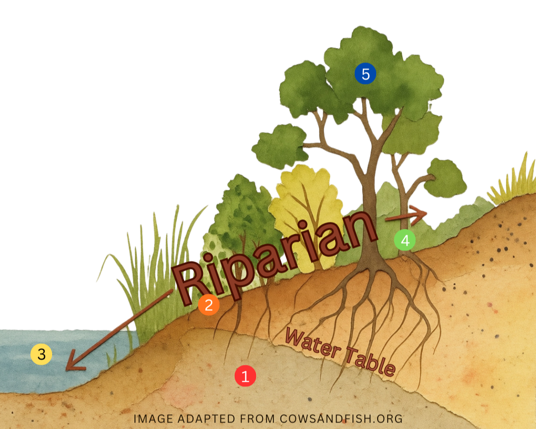
Riparian areas, also known as floodplains, shorelines, or green zones, are the transitional lands adjacent to bodies of water where the vegetation and soils are strongly influenced by the presence of water. They are formed as the result of water, soil, and vegetation interacting with one another, and are among the most productive and valuable of all landscape types. Riparian areas make up a small fraction of the Alberta landscape, but they are disproportionately vital to fish and wildlife, recreation, agriculture, and society. They perform a multitude of ecosystem functions, including water quality improvement, sediment removal, nutrient cycling, bank stabilization, and habitat management. In recent years, watershed management efforts have been focused on identifying priority areas for riparian restoration and habitat management.
Importance of Riparian Areas
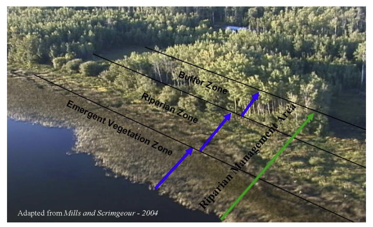
Schematic showing the different shoreline components included in a “Riparian Management Area” (image taken from Teichreb and Walker 2008)
-
Functions:
Store water and energy
Recharge aquifers
Reduce and dissipate energy
Why this matters:
Riparian plants slow, capture, and store runoff and floodwater.
Water absorbs into the soil and underground aquifers.
Stored water is gradually released, helping maintain water levels.
Slower-moving water reduces flood damage and erosion.
Vegetation reduces wave action and the force of flowing water.
Benefits:
More reliable water supplies for people, livestock, and wildlife.
Reduced flooding and property damage.
Improved drought resilience.
-
Functions:
Build and maintain banks and shores
Trap and store sediment
Why this matters:
Vegetation traps sediment and adds it to the soil.
Root systems stabilize banks and shorelines.
Reduced erosion helps maintain the shape and contour of shorelines.
Captured sediment improves soil structure and moisture-holding capacity.
Benefits:
Prevents loss of land from erosion.
Creates more stable and resilient shorelines.
Supports fish habitat and water health.
Speeds up recovery after disturbances.
-
Functions:
Filter and buffer water
Trap and store sediment
Why this matters:
Riparian vegetation captures sediment before it enters waterbodies.
Plants and soil microorganisms absorb excess nutrients.
Contaminants, pathogens, and pollutants are filtered out before reaching streams, rivers, lakes, and wetlands.
Benefits:
Cleaner water.
Reduced nutrient pollution and algal blooms.
Improved water clarity.
Healthier aquatic ecosystems.
-
Functions:
Maintain biodiversity
Why this matters:
Riparian areas create, connect, and maintain habitats.
They provide food, shelter, escape cover, and breeding areas for fish, wildlife, plants, and invertebrates.
Habitat connectivity allows species to move and disperse.
Benefits:
Greater abundance and diversity of species.
Healthier ecosystems.
Improved wildlife and fish populations.
-
Functions:
Create primary productivity
Why this matters:
Diverse plant communities support many other riparian functions.
Plant growth improves soil development.
Vegetation captures and recycles nutrients.
Productive plant communities provide forage and shelter.
Benefits:
Increased wildlife habitat value.
Better forage for livestock.
Stronger soil health.
Enhanced performance of other riparian functions, such as filtering water and stabilizing banks.
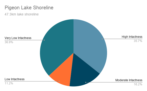
“Lakes across the province are increasingly becoming the focus of human activities that result in shoreline and riparian area modifications. These modifications, combined with increasing human activity and land use changes in the lake watershed, are leading to a degradation of water quality, which in turn is impacting the quality of life for residents and is threatening aquatic habitats and the species that rely on those habitats.”
Riparian Health
There is no standardized province-wide mapping method for defining and delineating the extent of riparian areas for hydrologic features. Due to this, it is challenging to manage these ecosystems because little is known about the location and size of riparian areas in the province. The most detailed evaluation of riparian conditions comes from site-specific field assessments and/or inventories of riparian areas. Practitioners are trained to evaluate a range of attributes, including vegetation type, structure, and composition, bank characteristics, soil attributes, and land use and disturbance. A final score gives a snapshot of whether a riparian area is “Healthy,” “Healthy, but with problems,” or “Unhealthy.” However, the information that assessments can offer for planning and management at the municipal, regional, or higher levels is limited.
A cost-effective way to assess riparian health across larger areas is through continuous aerial videography. This allowed the entire riparian area to be assessed at one time and provides a permanent geo-referenced record of the status of the shoreline. It is not intended to replace field-based assessments, but instead to complement them.
-
Metric 1: Percent cover of natural vegetation
Metric 2: Percent cover of woody species
Metric 3: Percent cover of all human impact and development
𝐼𝑛𝑡𝑎𝑐𝑡𝑛𝑒𝑠𝑠 = (0.15 × 𝑀𝑒𝑡𝑟𝑖𝑐 1) + (0.25 × 𝑀𝑒𝑡𝑟𝑖𝑐 2) + (0.60 × 𝑀𝑒𝑡𝑟𝑖𝑐 3)
High Intactness (>75-100): Vegetation within the RMA is present with little or no human footprint.
Moderate Intactness (>50-75): Vegetation within the RMA is present with some human footprint.
Low Intactness (0-50): Vegetation cover within the RMA is limited and human footprint is prevalent.
Very Low Intactness (0-25): Vegetation cover within the RMA is mostly cleared and human footprint is the most dominant land cover.

Intactness scores for he shoreline of Pigeon Lake and the left banks (June 2018)
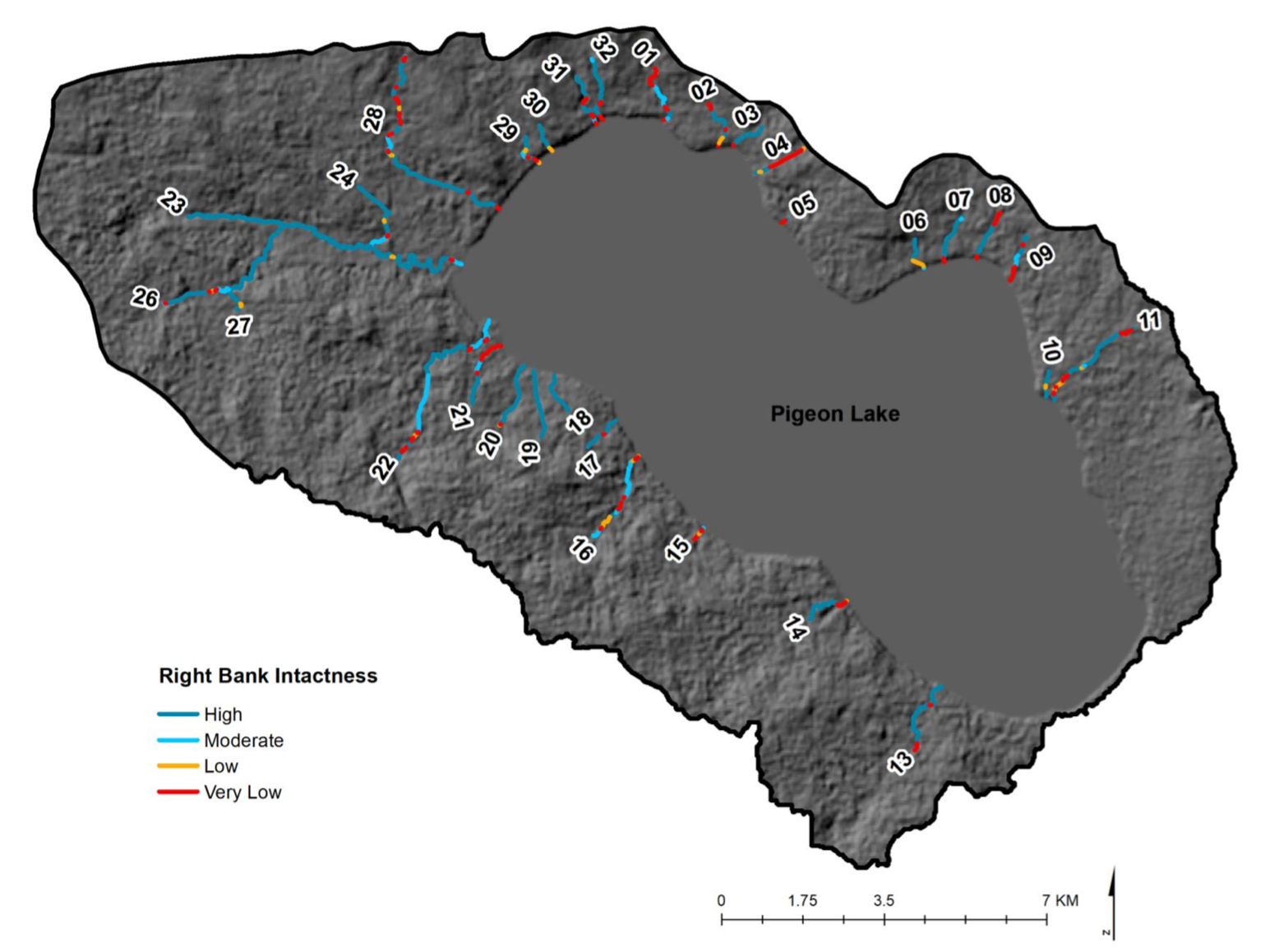
Intactness scores for he shoreline the right banks (June 2018)

High intactness: 86.6km
Moderate intactness: 27.9km
Low intactness: 10.1km
Very low intactness: 30.7km
High intactness: 16.9km
Moderate intactness: 7.7km
Low intactness: 5.3km
Very low intactness: 17.5km